The Archaeology of Development: Please Call Before You Dig

A colleague recently called me to ask for advice on how to respond to a developer who wanted to build a large lakeshore development within a registered archaeological site but did not want to obtain a Site Alteration Permit under Section 12 of the Heritage Conservation Act. From my conversation with my colleague, apparently the developer did not think they needed to consult an archaeologist or the Archaeology Branch because the area had been previously disturbed.

To make a long story short, the developer went ahead with the development and in the process destroyed significant intact archaeological deposits that were still present underneath the disturbed surface. Indigenous monitors on site stopped construction work and contacted the Archaeology Branch, who issued a stop work order. This resulted in irreparable destruction of important archaeological deposits – a non-renewable resource. It also resulted in long delays to the developer’s schedule and major unplanned costs.

Archaeologists have lost count of the number of times construction managers, developers, government officials, and landowners have said that an archaeological assessment or archaeological monitoring of a development site is not needed because, “…it’s all disturbed.” There have also been countless times an archaeologist had had to stop construction during monitoring for archaeological resources because there were intact archaeological deposits present in an area where everyone expected the entire work site to be previously disturbed.

This highlights the need for developers to engage qualified professionals to assist them with their compliance with relevant laws, regardless of how a work site appears on the surface. Professional archaeologists and indigenous communities together have the technical expertise and knowledge of the complex history of human presence in B.C. to provide expert advice.

Often, archaeologists can provide site specific recommendations that allow developers to move forward with some understanding of the archaeological costs involved with proceeding with development. Plans can be changed to avoid areas with high archaeological sensitivity, and still allow for development to proceed without the unnecessary and costly delays that usually give archaeology a bad reputation in the news.

While it is true that archaeological sites that have been previously disturbed may be managed in a different way from sites that have not been disturbed, it is also true that both intact and disturbed archaeological sites are afforded the same protection under the Heritage Conservation Act. To quote one of my mentors, “A disturbed site is still a site.”

Who foots the archeology bill?

There have been several articles published in various newspapers in the last number of years about homeowners facing unanticipated archeology bills.

A pretty common statement is, ‘Why isn’t the government paying for this? Why do I have to pay?”

The answer isn’t completely straightforward, but we have a user-pay system in B.C.

Most of the earlier archeological studies in B.C. were government-funded through the Ministry of Highways, which gave money to the Archaeology Sites Advisory Board to conduct work in advance of planned highways.

Throughout the 1960s and 1970s, but ceasing in the early 1980s, a handful of archeologists would set out in the summer with a truck, a tent and some sturdy hiking books.

They would survey the various transportation corridors to document archeological sites.

In the mid-1970s, BC Hydro was booming with proposed developments and it conducted archeological assessments in advance of hydroelectric projects.

This was done in conjunction with universities in the province, moving to using private contractors by the mid-1980s, thus creating the user-pay model we see today.

After a re-write of the Heritage Conservation Act and the implementation of the Forest Practices Code in the mid-1990s, a wider net was cast for the requirement of archeological study.

Then both larger and smaller-scale developers became required to conduct archeological assessments where conflicts with sites would occur, furthering the payment-responsibility model we see today.

There are many reasons why an archeological study or assessment may occur.

A small percentage of archeology conducted in B.C. is academic in nature.

In these cases, the archeology is paid for by the institution undertaking the research, usually universities or museums, as they stand to benefit from the research through published research papers and future grants for additional research and study.

In most cases, however, archeological studies are done through the process of cultural resource management, when a proposed development conflicts, or may conflict, with archeological sites.

In many cases, our government does still pay for archeological assessments with taxpayer dollars when the archeological assessment is being conducted as part of a project or development that will benefit the taxpayers at large.

Highways are a common example.

Utilities corporations, such as FortisBC and BC Hydro, pay for archeological assessments when developments to install or upgrade those services are required. This in turn is paid through the fees collected by users of those utilities.

This payment model also applies to smaller developers.

An individual or company planning a residential or commercial development is financially responsible for any required archeological assessments, just as they would be financially responsible for undertaking a geotechnical assessment prior to designing a housing foundation on a steep slope, for example, or a hydrology study in advance of installing a septic system.

As it stands, those who are positioned to benefit from a given development bear the costs associated with any required archeological assessments.

If the profits or benefits from a given development are not going to be shared with the wider public, the users who will benefit bear the cost, be that a large mining corporation with shareholders, a family-run winery or an individual homeowner building a dock.

As a side note, a common theme archeologists observe when people are upset about facing unexpected costs is that they purchased a property without being aware there are or could be archeological concerns.

Currently, protected archeological sites aren’t listed on property titles unless there is a legal covenant or notice of heritage assessment in place, but these are generally rare.

In some cases, individuals can avoid being surprised by making this a consideration before purchasing property and discussing it with their realtor, especially if they intend to develop or make substantial changes to an existing development.

This type of due diligence could help alleviated the unexpected nature of some of these situations.

Kim Christenson is a Kamloops archeologist.

Heritage is an Anchor of Society

In September 2016, I stood on a promontory overlooking the North Thompson Valley in Kamloops, contemplating the view with two other archeologists.

Below us was a golf course built where people had told me about artifact hunting, dust flying around two new housing developments underway and, right beneath our feet, the crumbled soil of a 7,000-year-old archeological site that had just been bulldozed.

excavator on idea.jpg

That was the moment we realized the need for this column.

We saw that, like many growing communities engrossed in the day-to-day challenges of development and expansion, heritage was being lost to neglect, disinterest and the rush to remake the world.

To help preserve the heritage in our midst, we aimed to open a dialogue with this community about history, archeology and Indigenous heritage.

We began the Dig It column to bring awareness to the importance of heritage to our community as a whole.

And we’re happy with how the conversation is going with you, the public.

To those of us who know, Kamloops is an archeological and historical wonderland, a rich timescape of more than 500 generations of human experience inscribed on the land.

Sharing that with KTW readers has been an engaging and eye-opening experience as we learn how to write and understand history together.

We are so grateful you are reading, happy you are learning, and delighted with all the positive emails and letters from interested and enthusiastic readers.

We see the columns pinned to bulletin boards in workplaces and shared with friends and colleagues and we know we’re going in the right direction.

However, as citizens, we can only do so much of this work.

At some point — and that point is now — we need our municipal leaders to learn, too.

We need our city to promote the value of heritage and to take up in earnest the recognition, preservation and education surrounding heritage.

Heritage is a public trust. Our governments are responsible for caring for it on our behalf and on behalf of our kids and grandkids.

In the present, lack of sustained, direct and meaningful support for heritage in our city is eroding the legacy we’re leaving to the Kamloops of the future.

Saving and savouring the unique and irreplaceable heritage of our region is at the heart of the Dig It column.

The way our past is remembered and preserved helps shape our society in the present and acts as an anchor for the society we wish to become.

As readers of this column, you’re becoming ambassadors of that heritage.

We hope you’re empowered by what you read here and we want you to share with others what you learn from Dig It.

Tell your friends and relatives, your classmates and your teammates what you’ve come to know.

And be sure to tell your elected representatives, too, because that’s how we spread the word that heritage matters.

Dig in — and continue the conversation.

The Archaeological Impact Assessment

The Archaeological Impact Assessment (AIA) is a stage of cultural resource management focussing on the impacts a project may have on archaeological sites. It is conducted by a qualified professional archaeologist, involving the visual inspection and subsurface testing of a project area followed by an evaluation of identified archaeological sites in relation to development activities.  An AIA may follow an Archaeological Overview Assessment (AOA), where documented archaeological sites or the likelihood of archaeological sites was noted.  Ideally, AIA is initiated early in project design to allow adequate time for the implementation of site-specific recommendations.

In BC, an archaeological site must not be damaged nor artifacts removed except under a Heritage Conservation Act (HCA) permit.  This also applies to an AIA, where subsurface testing may intercept buried archaeological deposits and artifacts collected.  An archaeologist’s HCA permit outlines the methods they implement during AIA fieldwork, analysis, and reporting for the proposed project.  The Archaeology Branch of the provincial government reviews applications and issues HCA permits.  First Nations bands in whose territories a project is proposed also review and comment on HCA permit applications.  Further, the archaeologist will apply for First Nations cultural heritage permits where bands have developed their own permitting systems.

The AIA fieldwork is conducted by crews composed of archaeologists and First Nations members. Following visual inspection, subsurface testing is initially conducted through manual shovel testing to discover and define the extent of buried archaeological sites.  Where there is a likelihood of deeply-buried archaeological sites, mechanical procedures such as auger or backhoe testing may be implemented.

If archaeological sites are found, the artifacts are collected and to-scale maps are produced of the site area.  Information is collected on the depth, extent, and type of artifacts recovered as well as any features encountered at the sites (e.g., cultural depressions, buried hearths, culturally-modified trees, etc.). In some cases, evaluative units measuring 1 m x 1 m may be excavated in a systematic manner to gain additional information about the archaeological deposits.  Following fieldwork, the archaeologist makes site interpretations based on analysis of the artifacts and field data.     

At this point, the archaeologist must evaluate and review the sites versus project plans so that management strategies can be formulated where impacts might occur. 

An evaluation considers the sites’ significance relating to scientific, public, economic, historic, and ethnic variables.  These relate to a site’s potential to generate understanding about human history; contribute to other disciplines or industries; provide educational, interpretive, or economic opportunities; and, reflect connections to current ethnic groups.  Ethnic significance is typically determined through discussion with the applicable First Nations for Indigenous sites.    

Project plans are then reviewed to identify the extent of possible impacts to archaeological sites.  These include direct impacts such as mechanical blading of site sediments and indirect impacts like on-going erosion to site areas or artifact collecting due to increased public access.  If it is determined that developments may alter a site, the management strategies take into account the type of impact, the level of disturbance, and the evaluated significance of the site.

The recommended strategies may include site avoidance, protection measures, excavation programs, and/or construction surveillance.  With the exception of site avoidance, these strategies may involve additional, possibly significant amounts of archaeological work and HCA permits. It is always preferable to avoid or reduce impacts to an archaeological site both in terms of preserving a culturally-important, non-renewable resource and to the cost-implications for proposed projects.

At the conclusion of an AIA, an HCA permit-compliant report must be submitted to the Archaeology Branch for review. The Archaeology Branch will respond in writing about the recommendations and outline requirements for any additional archaeological work relating to the project.  The report is also provided to applicable First Nations so they may remain knowledgeable about archaeological results and recommendations pertaining to their identified territories.

AIA Testing - shovel.JPG

The inconvenient truth of Indigenous archaeology

Last week, a pair of artifacts were identified on the site of a planned work camp related to the construction of the Coastal Gas Link pipeline in Unist’ot’en, a sub-unit of traditional Wet’suwet’en territory. The inland northwest LNG project has been in the news lately as authorities struggle with how to address the different jurisdictions of traditional hereditary governance and Indian Act band administration.

The unearthing of the artifacts, believed to date to at least 2,400 years ago, would not come as a surprise to most archaeologists or Indigenous people: 15,000 years of land use with technology dominated by stone tools guarantees an abundance of such evidence.

unistoten artifacts F Huson.jpg

Yet discussions in mainstream and social media have been full of accusations that Indigenous land defenders “planted” the artifacts, that they may not have actually originated in that place. Why have these artifacts stirred up this kind of debate and what does it mean about how we see ourselves and our history?

The answer to this lies in the four-century old idea of terra nullius, a key tenet of the Doctrine of Discovery, the philosophy endorsed by the Catholic Church that kicked off the age of exploration and led to the colonization of the global south.

Terra nullius, known as the “empty lands doctrine”, essentially said that lands not occupied by Christians were to be considered open and free for the taking, and that colonization of such lands (and religious conversion of their Indigenous occupants) was fulfilling god’s will.

Far from being history, terra nullius remains foundational to Canada’s national historical narrative. We see tend to see ourselves as pioneers, taming an empty wilderness, earning our place on this land by improving it, making it more productive, more profitable, in a way that past Indigenous owners did (or could) not.

Our origin story doesn’t have room for 500 generations of Indigenous people. It doesn’t acknowledge the depth, intensity and continuity of Indigenous relationship with this land. And it can’t grasp that more than 15 millennia of use has virtually carpeted the continent with archaeological sites, the marks of the all the ancestors. Admitting Indigenous precedence here is admitting that we took what wasn’t ours, and that to this day we live on stolen land. So we don’t.

So those artifacts in Unist’ot’en territory? Two beautifully made stone tools, knapped and used by an ancestor more than two thousand years ago? Those are the incontrovertible marks of the Indigenous past. So too are the names of the places they were found: in Unist’ot’en, at the confluence of Wedzin Kwah (Morice River) and Talbits Kwah (Gosnell Creek).

Those artifacts, and those names, represent an undeniable underlying title to this land that we have yet to come to terms with as a nation. The archaeology of Indigenous peoples will be seen as an inconvenience, even a ruse, until Canada makes peace with its past.

A couple of stone tools appearing where a pipeline was planned represent, in microcosm, the challenge of reconciling our occupation on unceded land. We can build on it, we can buy and sell it, we can profit from its resources, but we can’t wipe it clean and make it ours. We cannot erase the past.

Evidence of Skilled Carpenters in the Archaeological Record

Archaeologists are often only left with the non-perishable remains from past groups to learn details about their former lifeways. This typically involves stone artifacts and occasional charred bone fragments from long ago meals. While stones and bones comprise the bulk of artifacts discovered by archaeologists in the interior of BC, in reality these items only represent a tiny fraction of the materials utilized in the past. 

Soil conditions typically do not favour the preservation of organic materials in archaeological sites. After hundreds or even thousands of years buried in the ground, items constructed of plant or animal materials have long decomposed. There are circumstances where the conditions are ideal to preserve organic items, such as within glacial ice (as discussed in the previous Dig It column), but these situations are location-specific and incredibly rare.

It’s easy to focus on what is in front of us as archaeologists and forget about the diverse and complex array of items used in the past that were manufactured from wood and other organic materials that we rarely encounter. Luckily, certain artifacts that do survive in archaeological sites can provide clues about the types of perishable items manufactured and used. I recently experienced this while analyzing artifacts collected from an archaeological site excavated during the summer. While all of the recovered artifacts were manufactured from stone, the vast woodworking technology of the past was illuminated through the presence of certain types of artifacts.

Woodworking on a large scale was inferred through the presence of stone adze fragments and stone wedges. Adzes were used to cut down trees while stone wedges were used to split wood for various purposes. Finding these items within an archaeological site suggests that trees were felled and processed in the general area, perhaps for use as structural timbers for the abandoned pit houses located nearby.

Other wood processing tools were also present within the archaeological site, including a distinctive, slightly curved, stone scraping tool. This specially designed tool was used to strip the leaves, small branches, and bark from the stems of shrubs to form wooden shafts. These wooden shafts were important components of various tools such as digging sticks, spears, and arrows.

Oral history from Indigenous elders, community knowledge-holders, and ethnographic documents completes the picture by providing invaluable details about which types of plants were preferred for making wooden shafts. Saskatoon, yew, rocky mountain juniper, ocean spray, and hawthorn are a few of the local species selected because of both the natural straightness of the branches and strength of the wood. Many of these plants were observed growing within or near to the archaeological site under examination and most are ubiquitous throughout the southern interior.

These are just a few examples of specific woodworking tools found in archaeological sites and many more woodwork tools existed in the past. It’s not surprising that a variety of tools were designed for this purpose. Essentially every aspect of daily life had a component constructed from wood, ranging from timbers for housing, hunting and fishing technology, transportation, plant harvesting equipment, basketry, and so on. The use of wood was endless and past groups tailored a specific and expansive set of tools to work with this medium.

Although the wooden items of the past have often long decomposed, an archaeological site comprised entirely of stone artifacts can still provide information about past woodworking and help to fill in the details about daily life in the southern interior thousands of years ago.


Melt can reveal traces in ice patches

It is generally well accepted that climate change is real, that it is caused by humans, and that there are some big changes ahead for us. One well documented effect of climate change is that glaciers almost everywhere are shrinking. While the environmental effects of reduced glacial ice in alpine glaciers in Southern BC are not considered a good thing, it presents a unique opportunity to gain valuable insight about the past. As these “ice patches” that have been present on the landscape for thousands of years melt away, archaeologists in other parts of the country, including the Alberta Rockies and in the Yukon, conduct surveys of areas of recent glacial melt to look for archaeological traces. Incredibly well-preserved artifacts, including entire dart and arrow shafts with attached fletching and stone projectile points hafted with sinew, along with a variety of other organic artifacts including cordage, basketry, clothing, bone, wood, and sinew that rarely survive in other environments have been recovered. These kinds of artifacts are incredibly rare in other archaeological sites in BC, which makes the few that have been recovered a valuable resource.

Athabasca Glacier.jpg

The most well known “Ice Patch Archaeology” discovery in BC is that of Kwäday Dän Ts'ìnchi (Long Ago Person Found) first observed by bighorn sheep hunters in the far northwest of BC near the Yukon border, in the traditional territory of the Champagne and Aishihik First Nations. The remains of a young man and his travelling / hunting gear that were radiocarbon dated to between 300-550 years old were studied in detail, with the permission of the Champagne and Aishihik First Nations, revealing an incredible wealth of knowledge about past lifeways that archaeologists rarely get the opportunity to study.

The recent opportunities that climate change has presented to archaeologists has also challenged some long-held assumptions about land use by past peoples. Many archaeologists did not conduct surveys in high elevation areas because they assumed that past people would not have spent much time in the alpine, and that any archaeological sites present in these locations would be nearly impossible to find and would likely consist of small scatters of stone artifacts. This has partly led to a long-held assumption that past peoples have left little to no archaeological footprint in high elevation areas. Ice Patch Archaeology has both begun to open a window to a previously poorly understood part of past lifeways and seasonal hunting and gathering practices and challenge our assumptions about where some of the most valuable pieces of information about the past can be found on the landscape.

The work is challenging, as many of these areas are extremely remote, and in rugged, high elevation terrain. Based on the results of other Ice Patch Archaeology projects being carried out in other parts of western North America, the cost of completing these surveys is fairly high, and the archaeological finds are few and far between. Unfortunately, this has meant that many melting glaciers in BC remain uninvestigated for archaeological remains.

Delving into our deep love for dogs, Part 2

This is the second part of a two-part series on the history of our relationship with canines. To read part one, click here.

In the last Dig It column, we explored the earliest domestication of dogs in Europe and Asia and learned that wolves began lingering around the periphery of human encampments hundreds of thousands of years ago and were fully domesticated between 13,000 and 36,000 years ago.

In this column, I wanted to explore the introduction of dogs, or canis familiaris, to North America specifically.

Unlike their continental counterparts, dogs did not independently evolve from wolves present in North America, but instead arrived already domesticated with humans as early as 17,000 years ago, but most likely closer to 10,000 years ago.

While dog remains have been excavated within most, if not all, culture areas across the Americas, they do not appear as frequently in archeological sites as some may think, given their millennia-long association with humans.

Archeological data and records of oral traditions about dogs do exist, but recent genetic research into the history of domestic dogs in North America seems to offer the most plentiful insights.

A Peruvian hairless dog. - Wikimedia Creative Commons

Many of us would look at dog breeds such as catahoulas or Mexican/Peruvian hairless and assume they pre-date Columbus’ arrival and perhaps are even indigenous.

But multiple genetic studies conducted in the last decade have shown this assumption to be incorrect.

Most recently, a zooarcheologist from the University of Durham in England took part in a large multi-disciplinary study and reviewed the complete genomes from seven ancient dogs from Siberia and North America, 71 ancient mDNA samples (which show the mother’s lineage only) and more than 5,000 modern dogs.

The results indicate dogs were brought to North America in four waves: from Asia 9,900 years ago, into the Arctic by Thule people 1,000 years ago, along with European colonizers 500 years ago and in the early 1900s, when Huskies were brought into Alaska from Siberia.

This large genetic study further indicates the latter two canine-immigration waves essentially wiped out the dogs from former migrations, and that the dogs living with us today are the descendants of dogs brought here within the last 500 years.

Results of other studies generally concur with this notion, although not completely (see The Carolina Dog).

A geneticist from the Royal Institute of Technology in Sweden examined the mDNA in 2,000 modern dogs and found there was a large-scale replacement of existing dogs in North America with the arrival of European colonizers, but there are still traces of ancient DNA in modern dogs.

The closest detectable lineage between modern and ancient dogs in the Americas is, unfortunately, a venereal tumour. This contagious cancer is rarely seen in dogs today, but is present and can be genetically traced to a mutation in a dog that lived approximately 8,000 years ago.

So, what happened to the dogs that were here when Europeans arrived 500 years ago that caused this widespread replacement?

It is well documented that human colonizers introduced diseases for which the native populations had no natural immunity.

Their dogs were no different, bringing distemper, rabies and other diseases across the seas.

First Nations’ oral histories and European journals also indicate Europeans looked down on the existing indigenous dogs, doing their best to inhibit cross-breeding or outright killing them.

Before and after the arrival of European colonizers, dogs had — and continue to have — many roles in the lives of their humans: hunting partners, draft/pack/sled animals, protectors, used for religious and ceremonial purposes, used for hair (like the use of wool from sheep) and, of course, for the deep and fulfilling companionship that most of us associate with our furry friends today.

Kim Christenson is a Kamloops archeologist.

Delving into our deep love for dogs Part 1

Dogs — who doesn’t love them?

A 2017 summary of pet statistics released by the Canadian Animal Health Institute indicates that 41 per cent of Canadian households have dogs and more than seven-million dogs live in our homes and share our lives.

Until recently, we had two dogs (de facto children, really) living in our home. Thirteen years ago, I adopted one of those dogs, then a one-year-old, from the city pound.

He brought me untold amounts of joy and peace and, eventually, profound sorrow when we had to make that awful decision to say our final goodbyes as cancer and old age got the best of him.

The feelings of sadness and grief that come with the loss of a pet are seemingly universal.

It got me thinking about humans and our relationships with animals, specifically dogs.

Part of processing my loss involved researching the history of dogs and humans, an area about which I admittedly didn’t know much.

But I wasn’t at all surprised to learn there are countless articles written by archeologists who have researched the domestication of dogs and the thousands of years of history that intertwine dogs’ lives so closely with our own.

Researchers appear to agree that modern dogs are the descendants of wolves.

However, because they are archeologists, they generally don’t agree on how, where or when that happened.

Earlier theories suggesting humans captured wolf pups to raise seem to have given way to the more accepted theory that less aggressive/fearful wolves self-selected to live on the periphery of human encampments, scavenging scraps and eventually joining forces with hunting groups whose co-operation allowed for more successful hunts for both species.

Humans might be giving themselves too much credit for the domestication of dogs; evolutionary anthropologist Brian Hare suggests instead that dogs domesticated themselves in one of “the more extraordinary events in human history.”

The earliest evidence of overlapping activities between humans and wolves comes from archeological sites in England (400,000 years ago), China (300,000 years ago) and France (125,000 years ago), where wolf remains are interspersed with human remains, although their association is unknown and may have been coincidental.

Additional archeological sites in Belgium, Russia and Siberia have produced dog-like remains in association with the remnants of human activities that date between 13,000 and 36,000 years ago, although it is unclear if these were dogs or dog-like wolves.

Currently, the oldest known undisputed dog comes from an archeological site in Germany, where a dog was found purposefully buried with the remains of a man and woman more than 14,000 years ago.

Recent studies have conducted genetic analysis comparing canid remains from archeological sites to modern dogs.

In 2016, after tests were conducted on mitochondrial DNA (mDNA) from modern dogs, as well as the remains of 59 ancient dogs, a hypothesis was put forward that dogs were domesticated separately in Europe and East Asia between 17,000 and 24,000 years ago.

It is thought that either the two lineages blended or, more likely, that Asian dogs from the east replaced the western European breeds within a few thousand years and eventually became the variety of breeds we share our couches with today.

A 2017 study that looked at timing and genetics, however, suggests dogs were actually domesticated just once, several millennia earlier.

While a geographic region is not proposed in this study, a complicated calibration of the rate of genomic mutation suggests dogs diverged from wolves between 39,600 and 41,500 years ago.

The study also noted the difference in European and Asian species we see subsequently occurred as a genetic split approximately 20,000 years later.

One of the problems with conducting archeological research is, of course, the finite, and often yet-undiscovered, data that we have to create and test hypotheses.

For example, the 2017 study suggesting dogs came from a single line was only able to look at the well-preserved remains of two dogs that died between 4,700 and 7,000 years ago and compared the genetic mutations between those two dogs and modern dog to come up with the calibrated genetic mutation rate.

Researchers are limited by what is available to them — and often by current scientific methods.

As new finds arise and new methods are devised, we are constantly learning more about our past world and how it relates to our present. Hence, I suspect this discussion isn’t nearly over yet.

In part two of this series, we will learn about canine history, specifically in North America.

Kim Christenson is a Kamloops archeologist.

There’s no place like a (pit)home

November is Pellc7ell7ú7llcwten in Secwépemcúl’ecw. It means “entering the winter home”, the time of year when the food stores were put up, firewood was gathered, and families settled into pithomes for the long winter months.

The wood & earth pithome (c7ístkten̓, in Secwepemctsin) is one of the hallmarks of precontact life on the Interior Plateau. It’s an Indigenous architectural tradition that began millennia ago. Today, only traces remain of these round, half-buried dwellings so perfectly suited to our cold interior winters.

Photo 2018-11-27, 1 44 32 PM.jpg

When the first white men arrived in Secwépemcúl’ecw in the early 19th century, pithomes were the dominant type of residential structure. Villages of these houses dotted the major river valleys, ranging from a handful of pithomes belonging to closely related families to hundreds of dwellings making up bigger centers.

At Tranquille mouth, Brocklehurst, Sun Rivers, Monte Creek and Heffley Creek and elsewhere, pithome villages were occupied for thousands of winters. Picture the smoke rising from a crowd of conical roofs, the snow packed down on the winding trails connecting neighbours and kin.

Archaeologists have traced the Interior pithome architectural tradition back nearly 5,000 years. The earliest recorded pithomes on the Interior Plateau are near Monte Creek, on the South Thompson River east of Kamloops.

Occupation of pithomes here is the first good evidence archaeologists have of people settling into a pattern of sedentary winter living, where pithome villages became the anchor for a strategic kind of hunting-fishing-gathering that continued to exploit seasonally available resources all over the territory.

Pithome sizes varied over time, as social and economic patterns shifted, but the basics remained unchanged. Most pithomes were circular, though a few square and oval ones are known.

Inside, pithomes were often divided into four room areas that corresponded to the four cardinal directions. Sleeping platforms lined the walls and storage pits were dug into floors, and one or more hearth was found near the center.

Pithomes could be single-family dwellings measuring a few meters across, or be large enough to house large extended families. Some very large pithomes, measuring twenty meters or more across, are known to have been used as gathering places, like community centers or feast halls.

Constructing a pithome was labourious, and began with hand excavation of a large, bowl-shaped pit (earth was loosened with waist-high digging sticks and removed by the basketload). A group of adults and children working together could dig a big one in a day.

Over the pit, heavy timbers installed in the center supported a superstructure of rigid poles. Additional thinner poles were lashed on to form the roof, which was then covered with strips of bark, then packed with earth.

Photo 2018-11-27, 1 43 08 PM.jpg

The strong frame and thick earth insulation was so effective that homes could maintain comfortable temperatures from only very small fires and body heat. This feature made the homes all the more well suited to sparsely forested places like Kamloops, where fuelwood could be a limited resources.

The primary construction material for pithomes was the aptly named lodgepole pine, which were harvested from nearby uplands by the dozen. Smaller timbers and insulation needed replacement every few years, and occasionally the whole thing was burnt, cleansed, and rebuilt.

By about 1858, log cabins modeled on fur traders’ dwellings had become main housing in Kamloops area. Some were built over old housepit depressions, which were repurposed as root cellars.

Other pithomes decayed in place, leaving characteristic rimmed, bowl-shaped depressions. Many were dug up and looted for artifacts, ploughed over, or filled in. Today, there are only handful of sites that contain more than a few depressions, as most have been destroyed (often illegally) to make way for urban development.

These ancient pithomes are protected archaeological sites, silently holding age-old stories of home.

Photo 2018-11-27, 1 53 47 PM.jpg

Getting the Band Back Together Again: Education and Archaeology on the Tk’emlúps Reserve

Education is considered one of the critical pathways to empowerment for many, including First Nation communities who suffered trauma as a result of residential schools. In 1988, the Secwepemc Cultural Education Society (SCES) entered into a unique partnership with Simon Fraser University (SFU) designed to make university education accessible to aboriginal students. Classes in sociology, anthropology, Secwepemc language, as well as archaeology were taught at the new SFU-SCES campus located on the Tk’emlúps Reserve in Kamloops. In addition to these academic courses, archaeological field schools were also offered in Kamloops with a focus on providing indigenous students training with the skills and techniques necessary to become qualified field archaeologists. Many of the students that graduated from the SFU-Kamloops Archaeology field schools went on to become accomplished and respected archaeologists working to manage and protect cultural heritage resources for First Nation communities. These students represent the first generation of Indigenous Archaeologists and many remain important sources of knowledge and expertise for their communities. Following the formal end of the SFU-SCES partnership in 2004 and the departure of SFU from Kamloops in 2010, a real lack of education opportunities for First Nations in archaeology in particular became apparent. Training of new field assistants became the responsibility of consulting archaeologists who would offer the occasional week long certificate course geared towards teaching the basics of field survey and recording.

Photo 2018-08-23, 12 16 15 PM (1).jpg

Recognizing the need to not only train new archaeological assistants, but to also inspire a new generation of First Nation archaeologists Tk’emlúps te Secwepemc Natural Resources Department entered into a partnership with Camosun College in Nanaimo to run a pilot project offering their Archaeological Field Assistant Training Program here on the Tk’emlúps Reserve. This two-week long intensive program provided students with essential background education regarding heritage legislation, the local archaeological record, and the variety of methods that archaeologists employ while doing archaeological inventories.

Week one was spent in the classroom reviewing the necessary background information as well as training students in some of the core techniques used in the field such as orienteering with map and compass, using handheld GPS units, recognizing artifacts and culturally modified trees, and stratigraphy (i.e., layers of soil or sediments). Week two saw the exposed students to the rigors of field work where they participated in a permitted Archaeological Impact Assessment of a discrete development. This portion of the program involved initial pedestrian survey and assessment of archaeological potential of the development followed by shovel testing of these areas in search of buried archaeological sites. Following the discovery of three separate archaeological sites, students returned to the classroom to discuss the findings and to develop recommendations for the protection and management of these newly discovered sites. This curriculum allowed the students to gain firsthand experience in the steps that go into an archaeological assessment and the general process of doing field archaeology. The methods and techniques learned from the program have provided students with the necessary skills and knowledge to be employed by their respective communities as archaeological field technicians engaged in the survey, identification, and recording of archaeological sites.

Acknowledgements: Many thanks to Nicole Kilburn (Camosun College), program developer, who graciously allowed TteS to hold this course remotely and the rest of the Camosun staff who made this happen. Student funding was provided by ASETS and course materials were generously donated by Golder Associates, Interfor, Tolko, and Wood PLC.

The archaeology of salmon fishing

As the salmon race up the Fraser and Thompson rivers and back to their natal streams, fishers take to the waters all over BC’s interior to secure their catch. They’re part of a tradition practiced here since time out of mind.

And as Indigenous people have learned over thousands of years, what you catch depends on where, and how, you catch it.

In the past as now, fishing gear was tailored to specific environments and objectives. The kinds of artifacts and features left behind in the archaeological record can help us reconstruct how people exploited particular places, and how their practices change over time.

For example, fishing weirs constructed of woven wooden fences or layered stones were built across shallow river beds where fish could be counted on to appear in great numbers.

The effort required to build and maintain these trapping systems suggests that large groups shared both the intense labour and the larger harvest of fish.

These weir and trap sites can still be identified by geometric alignments of stones and stakes visible as the river levels drop.

In other kinds of settings, different kinds of equipment was used.

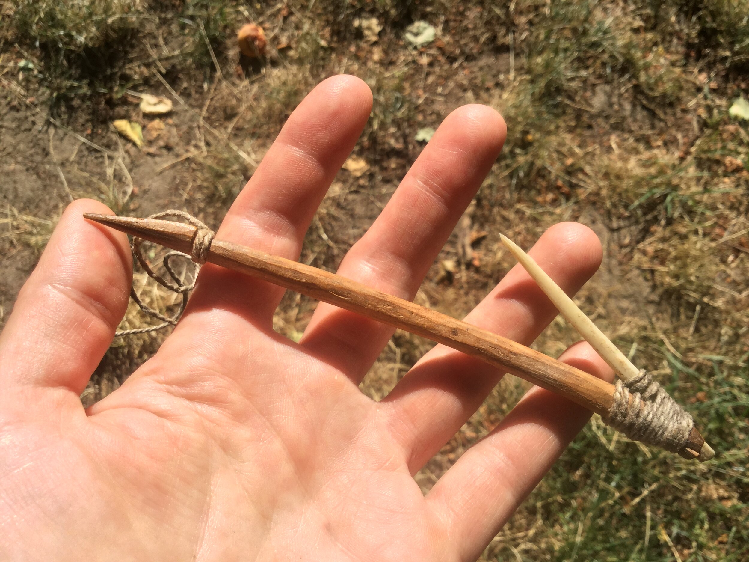
composite fish hook, Secwepemc Museum,  JHammond photo.JPG

In deep, swift moving water, a dipnet technique was (and still is) common. A dipnet consists of a long, strong pole fitted with a bag-shaped net on the end. In precontact times, the nets were made of plant fibers (split rose root and Indian hemp were common here), and fastened with sinew.

While a rare find due to decomposition of organic materials over time, archaeologists have found examples of these handles and netting where they’ve been preserved under water or mud. We also might find bone needles used to make and mend nets.

In calmer back eddies and pools, where fish move more slowly and are visible, a long wooden spear could be used to impale the prey. Special fishing spears called leisters are associated with this practice.

These are spearheads are fitted with twin barbed points set in a v-shape spreading from the end of the spear. A smaller bone or stone spear tip in the middle stabs the fish, while the barbed flanges hold it fast.

Because these are composite tools made of many small parts lashed together with organic fibres that decay, often archaeologists only find a few pieces and must work to reconstruct the technology, often looking to modern gear as examples.

On interior lakes through which the spawning fish pass, other methods were practiced. Near the shore, night fishing from canoes was effective. Here, small fires built on platforms lured the fish close to boats, where they were netted or speared.

In deeper waters, set nets were used much like today’s purse seiners, but on a smaller scale. Archaeological evidence for this type of fisheries includes carved or perforated stones used as net weights, and occasionally wooden net floats, or even fragments of the nets themselves.

On shore nearby all these fishing settings, archaeologists often find the corroborating evidence of artifacts and features related to fish processing: salmon bones, rocks distinctively cracked by the fires built for smoking fish or extracting their oils, small thin fish knives for filleting, or even open-work basketry used to transport the haul.

perforated stone net weight, JHammond photo.JPG

These varied fishing technologies developed here over millennia, as people observed the various ways that salmon move through different habitats at different times of year.

Many of these methods are the basis of today’s modern fishing gear, both recreational and commercial, showing us how ancient traditional knowledge lives on through the ages.

After the blaze: archaeology and wildfire recovery

As our second consecutive season of enormous wildfires winds down, the recovery is underway. Alongside foresters, range experts, road and bridge builders, archaeologists are combing the landscape and literally picking up the pieces left behind after the blazes.

In most of BC, we’ve been fortunate not to lose many homes or buildings, but the fire’s impact to the land itself is substantial: vast tracts of forest burned to nothing have left bare slopes and loose silt. Fencelines that defined cattle ranges are gone. Fireguards and ad hoc roads made in the effort to contain the fires have also scarred the land.

Photo 2018-11-15, 1 01 06 PM.jpg

The work of stabilizing slopes, rebuilding fences, reclaiming fireguards is just beginning. In all of these settings, archaeological sites long hidden under the surface have been exposed, and the scientific information and cultural knowledge contained in these sensitive and finite cultural resources are at risk.

In archaeology, fire recovery is considered in two main areas: the impacts caused by fires themselves, and the often much more serious damage caused by the heavy machinery used to fight the fires.

Impacts to sites from the fires generally includes destabilizing site deposits, as ground cover, tree roots, and organic layers that have protected buried sites are burned off. This means that sites long held in place under forests are now exposed, and at risk of literally slipping away.

Severe mechanical damage is caused to sites by plowing through forested landscapes to create breaks, helipads, and staging areas. Features like housepits and earth ovens are easily destroyed and artifacts can be broken and displaced.

In the southern interior, caring for these remains in the wake of the fires has become a cooperative project of local First Nations, archaeologists, and Ministry of Forests, Lands and Natural Resource Operations and Rural Development.

IMG_0317.JPG

As you read this, archaeologists and Indigenous field technicians are surveying the fire zones, recording new sites and assessing damage to known ones. This triage work will continue through the fall, and into next year, as we decide which sites need attention and what, if anything, we can do to preserve their value.

Fireguards in particular are providing an exciting opportunity to get a glimpse at terrain we’ve seldom had a chance to see. Fireguards are a swathe of ground about a tree length wide plowed around a fire’s perimeter in an effort to contain it, and they’re giving us an excellent look at terrain commonly overlooked by archaeological researchers.

In our area, hundreds of kilometers of fireguards made to contain the giant Elephant Hill wildfire have been surveyed, painstakingly walked by crews looking for signs of archaeological deposits.

And what we’re finding is refining how archaeologists think about precontact land use. While we usually focus our attention on residential occupation in large river valleys, we’re now finding more and more sites in all kinds of different settings, from headwaters to valley bottoms.

Tracing the obsidian trade routes of yesteryear

Obsidian, a naturally occurring volcanic glass, was highly valued by people living in the southern Interior in years past.

Even today, mineral enthusiasts value obsidian for its aesthetic qualities.

When manufactured into stone tools, the edges are razor sharp (obsidian blades are still used in certain surgical applications because they are much sharper than surgical steel).

Obsidian tools are rare in archological sites in the Kamloops region. When they are found, they are usually heavily re-used and re-sharpened, having been well cared for by their owners.

While further research may reveal a local source of obsidian in the southern Interior, archeologists have not identified a local source for this highly valued material. The nearest sources, or quarries, hundreds of kilometres away: Glass Butte in southeastern Oregon; Bear Gulch in Yellowstone National Park, Idaho; two sources at Itcha Ilgachuz and Obsidian Creek in Tsilhqot’in territory, west of Williams Lake; Mount Garibaldi near Squamish; and Mount Edziza in Tahltan territory in northwestern B.C.

Not surprisingly, archeological sites near these source quarries often contain large quantities of obsidian artifacts.

It appears to have been highly valued by many cultural groups, however, because small numbers of obsidian artifacts can be found almost anywhere in B.C.

When found in archeological sites, obsidian can provide archeologists with important clues about ancient trade routes and exchange networks.

The source quarries of obsidian artifacts can be determined using an analysis technique called X-ray fluorescence.

Because obsidian is formed from the cooled lava flows of ancient volcanic eruptions, each obsidian source contains a unique chemical signature, which can be measured using this technique.

X-ray fluorescence is fast and inexpensive and has become a popular tool for archeologists in B.C. and elsewhere to gain a little more insight into how people lived.

Obsidian from the Idaho and Oregon and the Edziza and Obsidian creek localities, as well as from sources further afield, have been recovered in the southern Interior of this province.

Obsidian has been recovered from sites dating as far back as some of the earliest recorded sites in the Kamloops area and as recently as the 19th century.

This tells us established long-distance regional trade networks with other cultural groups must have existed several thousand years ago and that obsidian remained a highly traded resource for a long period of time.

While much more research into ancient trade networks is needed, many archeologists, myself included, love to speculate about uncommon or rare artifacts found during an archeological study.

Obsidian was likely mined in surplus by the cultural groups who had the rights to the quarries and traded to neighbouring communities for various goods, such as jade, dentalium shell, food items, copper, basketry, and other “exotic” materials.

Obsidian appears to have been traded into the Kamloops area from the Columbia Plateau to the south and from the northern Interior (and, possibly, from the B.C. Coast).

It is probable that obsidian traded hands several times before arriving in the Kamloops area, gaining value with every exchange.

By the time it arrived in the local area, it had travelled hundreds of kilometres and is possible only wealthier families could afford to trade for it.

While the practical uses for obsidian are obvious, it is possible it was also a symbol of wealth for those who had tools made from it.

Ramsay McKee is a Kamloops-based archeologist.

A 5,000 year old Kamloops story

The dust hasn’t settled yet, but recently in Kamloops a 5,000 year old archaeological site was unearthed during construction. The site is one page in a book. When we read it along with all the others, we start to get a big-picture view of the human lives lived here over millennia.

In this space we often talk about practical and technical aspects of archaeology, and how Indigenous traditional knowledge and stewardship inform and support our interpretations of the past. All of those methods and perspectives help to build the story, too.

Today, let’s look at what archaeology tells us about those lives, 5,000 years ago, right here where the North and South Thompson Rivers come together at Tk’emlups.

5,000 years ago, the climate was a bit warmer and drier than today. Very dry desert and grasslands were more extensive, and roamed by large herds of elk, antelope & bighorn sheep and deer that provided a steady food source.

The mild climate allowed people to live lightly: shallowly excavated “mat lodges” topped with fiber mats were used in winter, and portable, open-air shelters the rest of the year, taken along as people traveled to harvest seasonally available plant and animal resources throughout the territory.

5,000 years ago, the population here was genetically diverse, part of the evidence for direct and indirect contact with the coast and the Columbia Plateau. Travel and trade in these regions brought exotic goods to Tk’emlups, like Oregon obsidian, and exotic shell beads from coastal regions.

Sometime shortly before 5,000 years ago, people from Coast Salish lands began traveling regularly into this part of the Interior after the prolific salmon runs. At first these were seasonal trips by small family groups, who returned to winter in coastal valleys. Gradually, though, they made kin and began to stay. This became what’s known as the Salishan migration.

For several centuries, there was a slow, transitional process of mutual acculturation-exchange of genes, technologies, ecological knowledge, and languages. We see this in archaeological sites where Interior/Coastal traditions and styles commingle. We see it too, in the roots of the ancestral Secwépemc language family, created as the language of Coyote’s people merged with that of the Salmon people.

Shortly after 5,000 years ago, the climate was shifting. Winters became colder and wetter. People began to build deeper, sturdier, more insulated pithomes in sheltered valleys, and a cozy settled winter became part of the seasonal round.

Around 5,000 years ago, as life became more river-oriented, people turned less often to deer, elk and other upland foods and more and more to salmon. Smoking fish was widely adopted to preserve winter supplies. By 5,000 years ago, salmon made up about 40% of Secwepemc dietary protein.

But people’s diets were still impressively diverse: rabbits, beaver, marmot, muskrat, porcupine, bear, turtle, duck, loon, goose, freshwater fish and mussels, and of course, deer and elk, were in regular rotation around Secwepemc ancestral hearths. Not to mention a bounty of roots, shoots, and berries.

Around 5,000 years ago, popular goods included leaf-shaped and lance-like tools that function as knives or projectiles depending on how you haft them. Bone points of all kinds were super common too, and could be put to many uses, from composite fish hooks to rakes used to collect small fish, mussels or berries, or as simple hair or blanket pins.

Even after 5,000 years ago, climate was still a bit unsteady. Characteristic Thompson silts, borne by winds, were deposited in thick layers around this time. For archaeology, this means older sites are often deeply buried and hard to find.

When you look out across the Kamloops landscape, think of this page from 5,000 years ago. Imagine all the other pages too. These lands are saturated with history, these lives are marked on the land. All we have to do is read the story.

The steps that form an archaeological review

Archaeological sites on provincial and private lands are protected in BC under the Heritage Conservation Act (HCA).  Each site is unique and provides information on the cultural adaptations people made to their natural, social, and non-physical environments.  Many provide a tangible link between today’s First Nations, their ancestral groups, and the landscape.  Once disturbed or destroyed, sites cannot be replaced.  

When a developer proposes a project, government agencies or First Nations (for on-reserve lands) may direct them to work with a professional archaeologist before the project is approved for construction.  Initiating archaeological review of a proposed project early in its planning stages means that avoidance or mitigation strategies can be designed before impacts to archaeological sites have occurred. Taking a proactive approach reduces frustration and cost while protecting a non-renewable resource. 

An archaeological overview assessment (AOA) is frequently the first step in this process. 

The AOA is a tool to define the archaeological potential (e.g., areas with high, moderate, and/or low expectations for sites) of a project area as well determine the presence and nature of documented archaeological sites.  It is conducted following provincial guidelines and standards but does not involve an HCA permit.  The first step typically includes reviewing the Remote Access to Archaeological Data (RAAD) system, an on-line database of archaeological information maintained by the provincial Archaeology Branch.  The archaeologist will then examine the reports associated with the RAAD results, as well as other archaeological, ethnographic, historical, environmental, and terrain data.  In this way, the archaeologist gains an understanding of details or gaps in information relevant to the proposed project area and generates expectations for what archaeological resources may be found.

The archaeologist will contact First Nations whose territories overlap with the project area to notify them about the proposed project and associated AOA.  This provides an opportunity for First Nations to contribute unpublished traditional, cultural and/or archaeological knowledge that may not be otherwise available for review. This notification and information sharing process is a means for the archaeological community to maintain respectful relationships and participate in First Nations heritage policies. 

When it is not possible to delineate a project area’s archaeological potential during the background review, the archaeologist conducts a direct-observation, preliminary field reconnaissance (PFR) as part of the AOA.  The PFR is also conducted to provincial standards and guidelines. It is standard practice for First Nations members to participate in the PFR, which provides cultural knowledge and land use interpretation to improve AOA results. Documented sites within the project area are visited to verify or refine what has been previously recorded.  In addition, surface artifacts or features may be observed at newly-identified archaeological sites, increasing knowledge of the project area.  However, artifacts are not collected nor is any digging conducted during the PFR.

At the conclusion of an AOA, the archaeologist prepares a report for the proponent.  It will include a map that outlines the identified areas of potential and the locations of any archeological sites. The archaeologist assesses the anticipated project impacts in light of the desktop and/or PFR results.  Recommendations are then provided for further archaeological work if project activities cannot avoid identified areas of concern. Generally, the earlier in a project schedule that archaeological assessment is conducted, the easier it is to adjust the project to avoid areas of concern. The report is provided to the project proponent, identified First Nations and, as necessary, to regulatory agencies. 

PFR2.jpg